

Arroyo Seco Foundation
Comments on the
US Army Corps of Engineers LA River Ecosystem Restoration Feasibility Study
Project Alternatives
The Arroyo Seco offers an unparalleled opportunity for meaningful habitat, stream restoration and public access on the Los Angeles River system. The Confluence together with the main stem of the Los Angeles River links the three largest parks in Los Angeles, all with significant habitat value, and provides the key linkage to another 22 linear miles of the river system, extending all the way into the Angeles National Forest. The Arroyo Seco links downtown LA with the San Gabriel Mountains, including even wilderness areas there. The AS Confluence provides a linkage to a vital habitat, wildlife and transportation corridor, joining the San Gabriel Mountains and the San Rafael/Verdugo Hills to the Santa Monica Mountains. As the LA River Revitalization Master Plan notes; "Together, the Arroyo Seco and the Los Angeles River connect the three largest parks in the City of Los Angeles- Griffith, Elysian, and Debs-all of which have significant natural habitat areas. North/east of the City boundary, the Arroyo Seco is lined with nearly continuous open space leading to the Angeles National Forest."
The Arroyo Seco Confluence is a key spot for flood management and water quality improvements, draining a key urban watershed of the LA River system. This site can produce real and substantial flood management and water quality results, as illustrated in the Los Angeles River Revitalization Master Plan.
In addition to the LAR Study, the US Army Corps of Engineers has initiated an Arroyo Seco watershed restoration feasibility study with the County of Los Angeles, and the cities of Los Angeles, Pasadena, La Canada Flintridge and South Pasadena that provides an invaluable opportunity to leverage and multiply LA River enhancements. This second study will complement the LAR Study and provide opportunities to multiply its benefits through an expanded watershed approach.
Another key consideration is that most of the land in the immediate area of the Arroyo Seco Confluence is already owned by the City of Los Angeles or other public agencies, which offers potential for significant improvements quickly.
Given the rich potential of this site and the work already underway, ASF would like to propose some simple, straightforward and relatively inexpensive alterations to the treatment of the Confluence in the LAR Study. We have illustrated key points in the series of pictures attached.
Historic Conditions
A careful examination of a historic photograph of the Arroyo Seco Confluence from the 1920s reveals a lot about how its ecological significance can be restored and integrated into the LA River Study. The photo shows the Arroyo and the LA River in a relatively natural state, largely free of concrete. The Arroyo stream has space to flow and is lined by significant riparian habitat. The Avenue 19 Bridge in the foreground has four major spans that measure approximately two hundred feet wide and give significant capacity to handle flood flows that come down the Arroyo from the San Gabriel Mountains and Valley. On the north (or left) of the bridge is the old Figueroa Street, which subsequently became the Arroyo Seco Parkway, aka Pasadena Freeway. There are service roads on both sides of the Arroyo as well as a street, labeled "Avenue 19" on the southern side of the stream zone.
Current Conditions
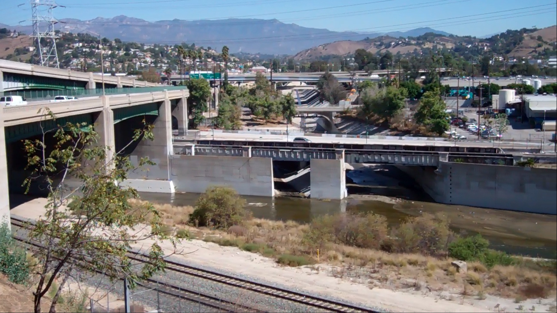
The next picture illustrates conditions at the Confluence today. Note that there are now only two spans in the Avenue 19 Bridge, only one of which allows water to flow from the Arroyo into the River. The other opening is at the service road on the north side of the stream and permits maintenance vehicles to enter the River and the Arroyo Channel but is now blocked by a concrete retaining wall. The Arroyo stream zone has been lined with concrete and the Confluence significantly narrowed. Figueroa Street has been transformed into the freeway. The road labeled Avenue 19 on the previous picture has been eliminated; the mouth of the Arroyo has been narrowed, and a parking lot has been built to the south of the stream. There is no habitat in the stream zone, although there are significant trees along the rim of the Arroyo.
Double Barrel on San Fernando Street Bridge
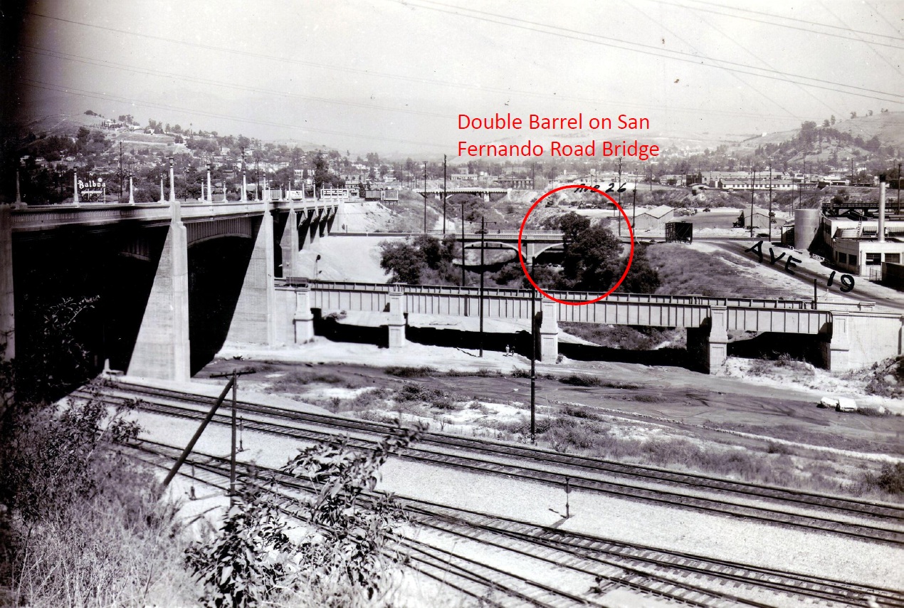
There is an important element on the historic picture of the Confluence, which you might have missed, that is important to consider for the restoration of the Confluence and its potential. The San Fernando Street Bridge, upstream of the mouth of the Arroyo, has two spans or barrels, which allow for improved flood capacity and additional stream zone habitat. That second span was filled when the Arroyo was channelized in the late 30s, but it still exists today in a state that would be relatively easy to restore and would greatly enhance the area.
Additional Span on the Avenue 19 Bridge
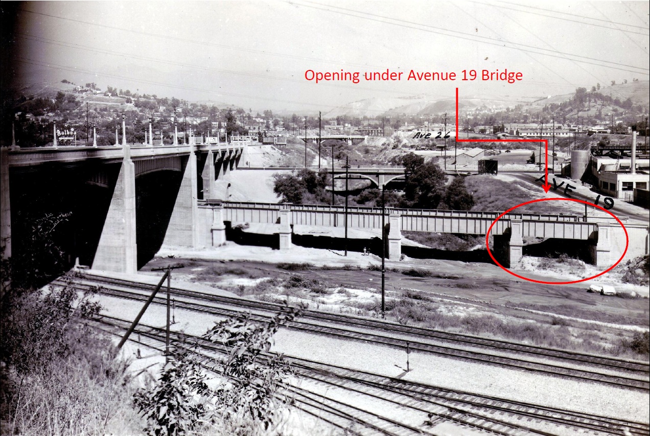
It is important to note that all four of the spans in the historical picture allow flood flow to pass into the main stem of the Los Angeles River. Another element to note is the span on the south side of the Avenue 19 Bridge, 45 feet wide, which was covered up when the Arroyo stream was channelized. This span, which only passed water in high flow events, shows riparian habitat present.
Supporting Pillars on the Avenue 19 Bridge
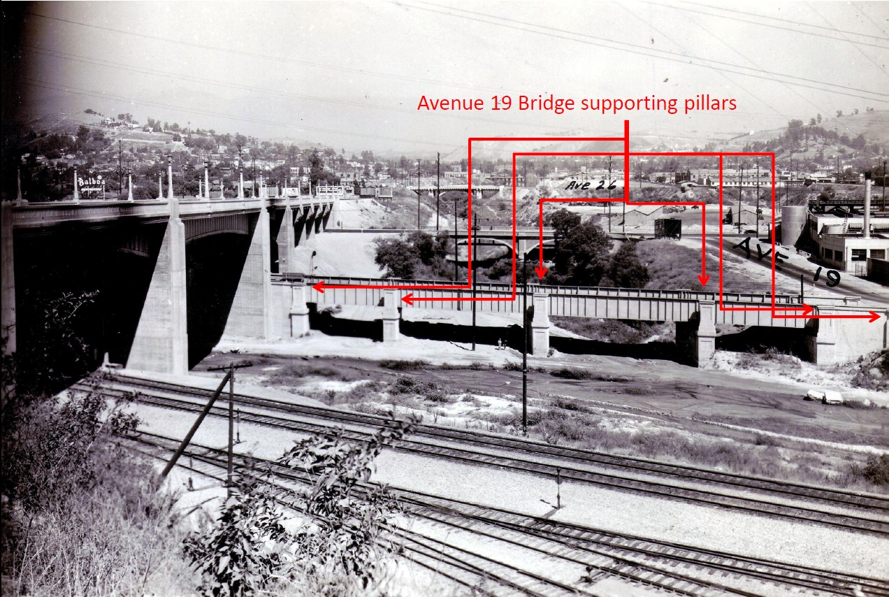
Note the supporting pillars on the historic Avenue 19 Bridge, the key structural elements illustrated by this picture.
Supporting Pillars on the Reconstructed Avenue 19 Bridge
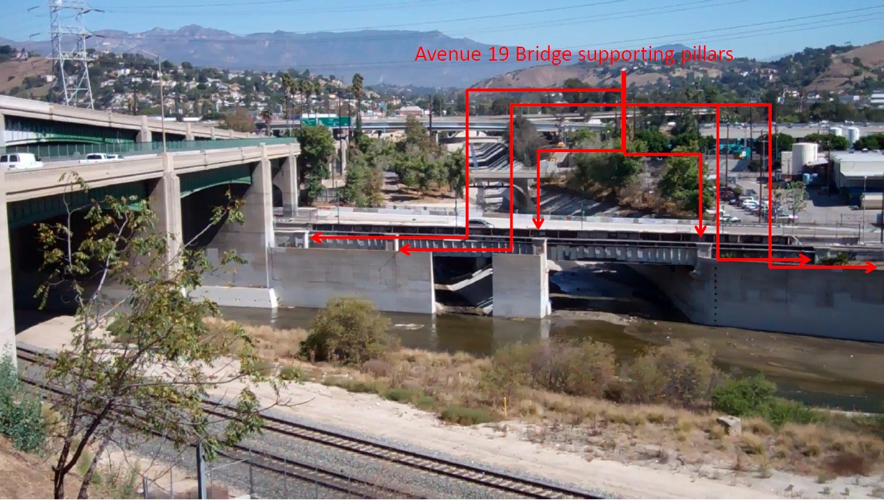
The Avenue 19 Bridge was rebuilt by LA Bureau of Engineering in 2009. John Koo was the project manager. The design and construction of the Bridge took into account the historic character and future potential of the Arroyo Seco Confluence. It was carefully designed to allow for opening up the Confluence and enhancing its potential for stream and habitat restoration. It envisioned and allowed for opening up the southern span on the newly rehabilitated bridge. This picture illustrates that the supporting pillars have been protected in the new design and may be sufficient to bear the load of the bridge.
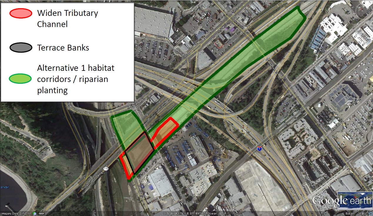
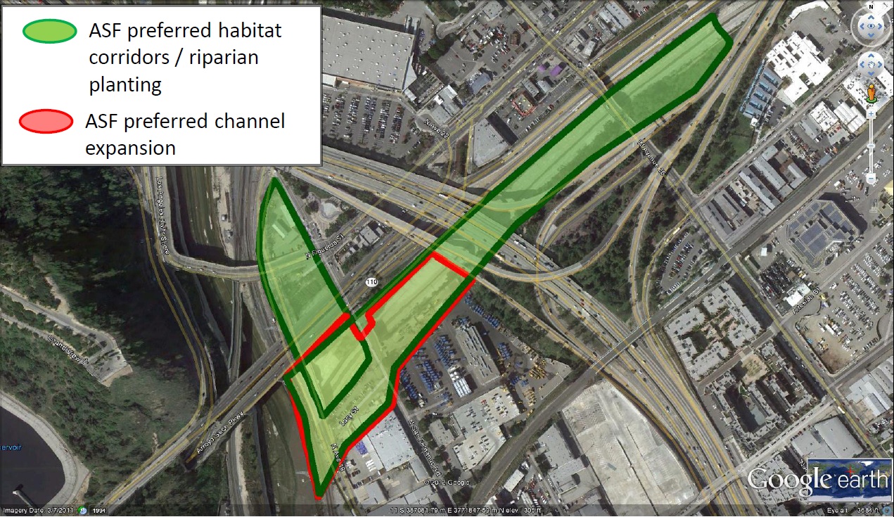
Alternative 1
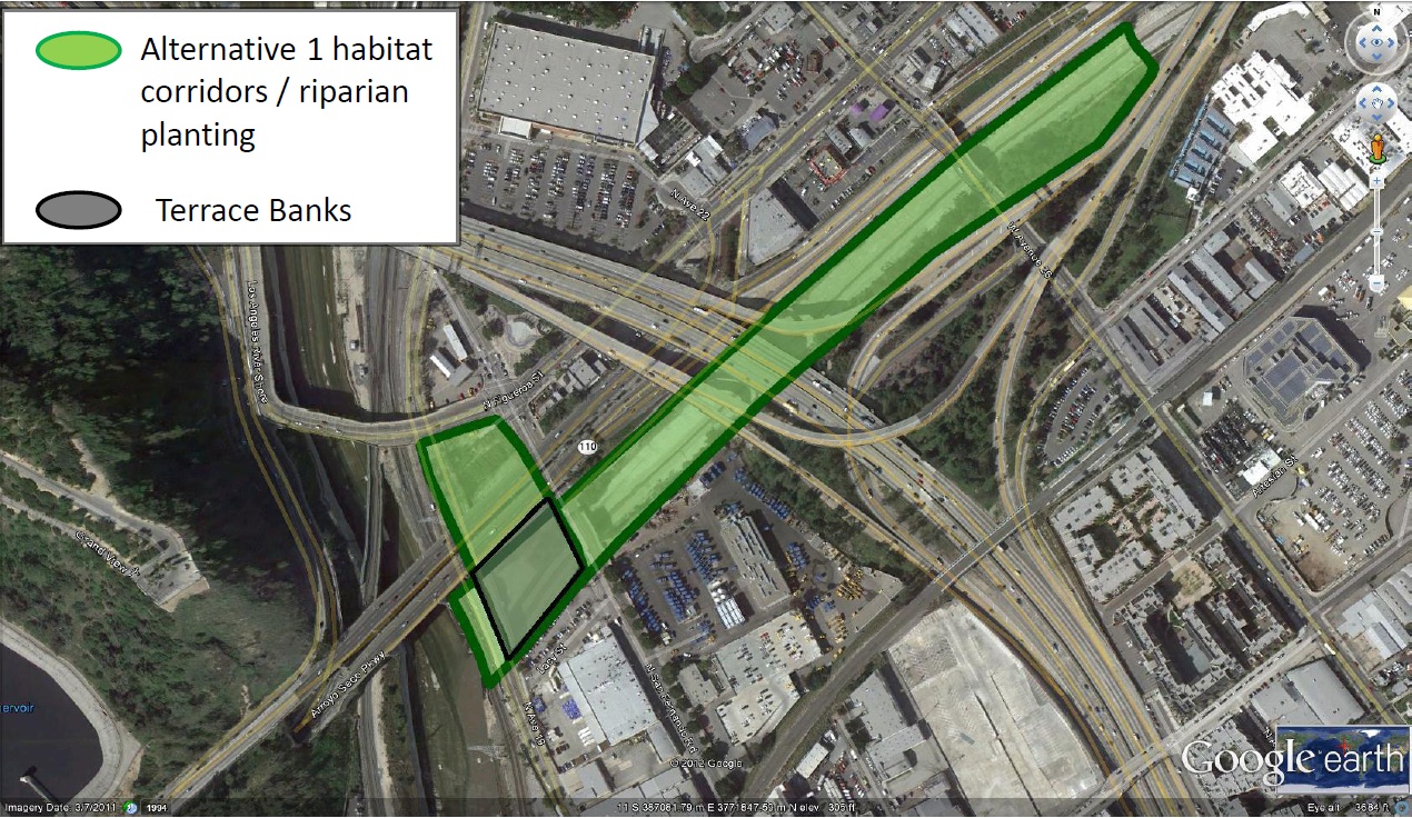
The next three pictures illustrate the treatment of the Arroyo Seco Confluence in the LAR Study draft as presented on April 25, 2012. Alternative 1, the cumulative option, provides for habitat corridors with riparian planting for half a mile up the stream from the Confluence and terraced banks in the zone between the Avenue 19 Bridge and the San Fernando Bridge. There is, however, apparently no expansion of the mouth of the Arroyo at the Confluence.
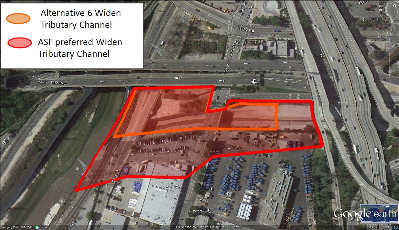
Alternative 6
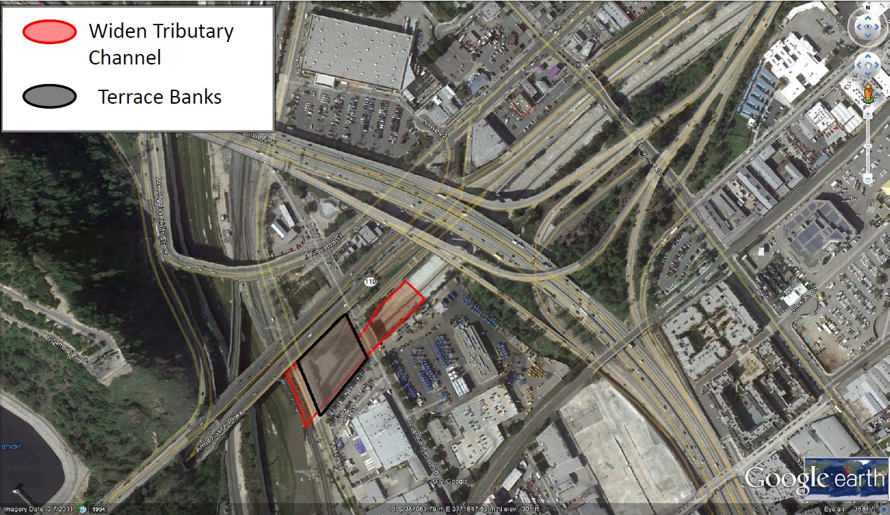
Alternative 6 would widen the tributary channel and terrace the banks of the Arroyo between Avenue 19 and San Fernando Road. Riparian restoration in the stream zone, however, is not incorporated, missing a significant potential for habitat improvements.
Alternative 8
Alternative 8 would combine the three elements considered in Alternatives 1 and 6, incorporating channel widening, bank terracing and habitat restoration upstream. Of the alternatives presented in the draft, Alternative 8 provides for the greatest habitat and ecosystem benefits.
City of LA Cornfields/Arroyo Seco Confluence Specific Plan
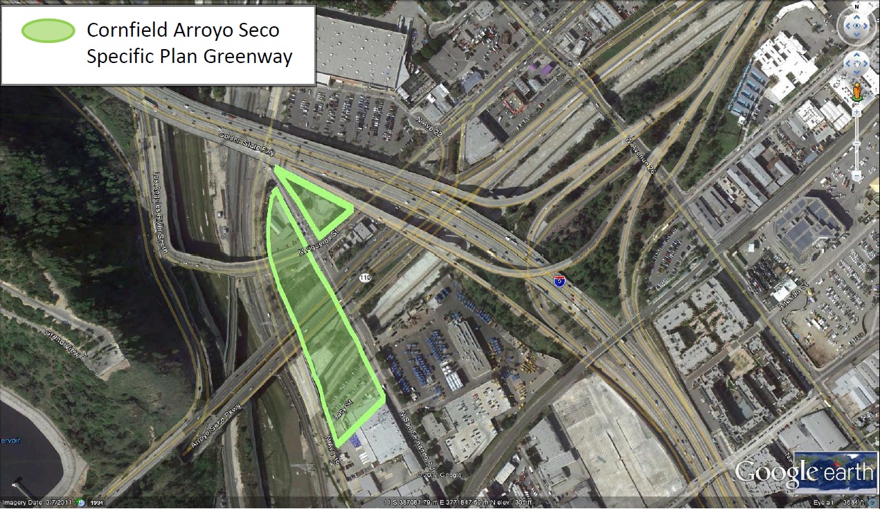
The Cornfields/Confluence Specific Plan, prepared by the City of Los Angeles Planning Department, illustrates a greenway area at the Confluence that extends across Figueroa Blvd. and includes an additional wedge north of the Riverside Drive Bridge, which is now being rehabilitated. Across from that wedge is the Confluence Plaza Park recently developed by the Mountains Recreation and Conservation Authority. The greenway also extends to the south of the Arroyo stream and includes the parking lot and part of the building that is now occupied by Angelica Linen Service.
USGS Confluence Study
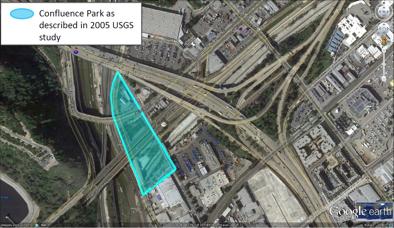
In 2005 the United States Geological Survey prepared a key report that studied the potential of the Confluence area, "Geological, Hydrological, and Biological Issues Related to the Proposed Development of a Park at the Confluence of the Los Angeles River and the Arroyo Seco, Los Angeles County, California." This illustration shows how that study envisioned the restored area of the Confluence.
County Bike Plan and Connection to Gold Line Station
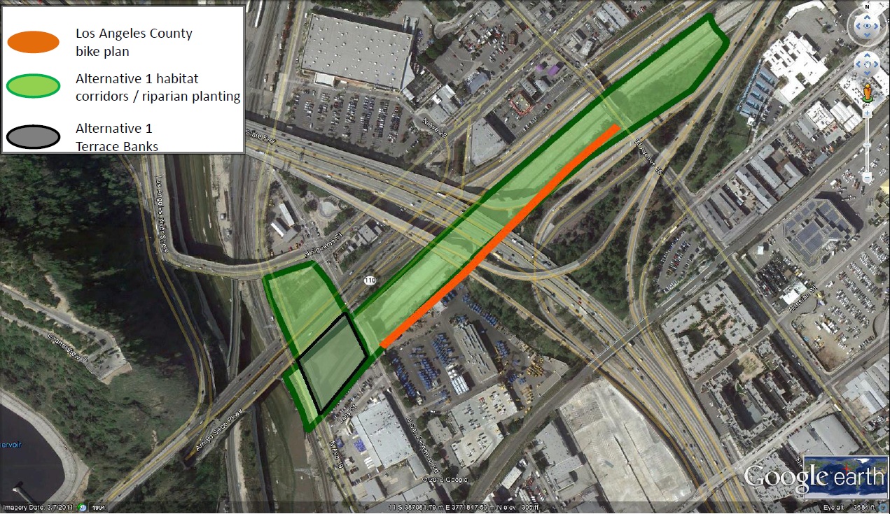
The County of Los Angeles Department of Public Works has developed a plan for the Arroyo Seco Bike Path to be built from Avenue 26 near the Gold Line train station underneath the 110 freeway to San Fernando Road, just upstream of the Confluence, where it will proceed to connect with the LA River Bike Path. The project is included in the County's approved Capital Improvement Program and Caltrans has approved the right of way. Construction will begin in 2014. This path will provide an important link for bicyclists and pedestrians to the local transportation network and enable people from all over Los Angeles County to access the Los Angeles River without the use of a car.
ASF Preferred Plan
ASF presents this additional alternative for the Confluence area that incorporates the work that has been done by a variety of agencies and stakeholders, including USGS, City of LA Planning, MRCA, County of Los Angeles, and the Arroyo Seco Foundation. This alternative takes into account the specific advantages of this site, such public ownership of land, public access, accessibility by public transportation, trail, habitat and wildlife benefits from expanded connections to the extended watershed.
This plan includes additional tributary channel widening to approach the historic stream zone and corridor. The plan will allow a dramatic increase in ecosystem values from a broader habitat corridor and riparian planting. To achieve these benefits, it is necessary to open up the mouth of the Arroyo as this plan envisions. This plan also provides unparalleled public access because of the connections with the County of LA's bike trail, nearby LA River Trail, and the nearby Gold Line station at Avenue 26, just upstream of the Confluence.
The enhancements we propose could achieve maximum benefits in habitat units at a relatively low cost because of the natural advantages of the site. We urge the LA River Office and the USACE to consider the ASF alternative carefully.
ASF Preferred Plan - Aerial View from South of Site
This figure illustrates the difference between the relatively modest channel expansion in Alternative 6 and the ASF alternative. We note that the expansion considered in the LAR Study for the Verdugo Wash Confluence is considerably larger than even ASF's proposal and includes the purchase of a significant amount of private property. The ASF proposals does envision acquiring some property now occupied by Angelica Linen Service and a portion of the LA Bureau of Sanitation yard on the east side of San Fernando Road. (The Bureau of Sanitation has allowed a thirty foot easement through their property for the County's bike path.) The expanded area included in the ASF proposal is consistent with the planning included in the USGS study and the Cornfields/Confluence Specific Plan.
LA River Revitalization Master Plan Concept
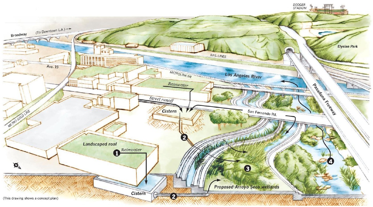
For purposes of comparison, this figure shows the concept rendering for the Arroyo Seco Confluence that was included in the Los Angeles River Revitalization Master Plan.
Comparison of Concepts
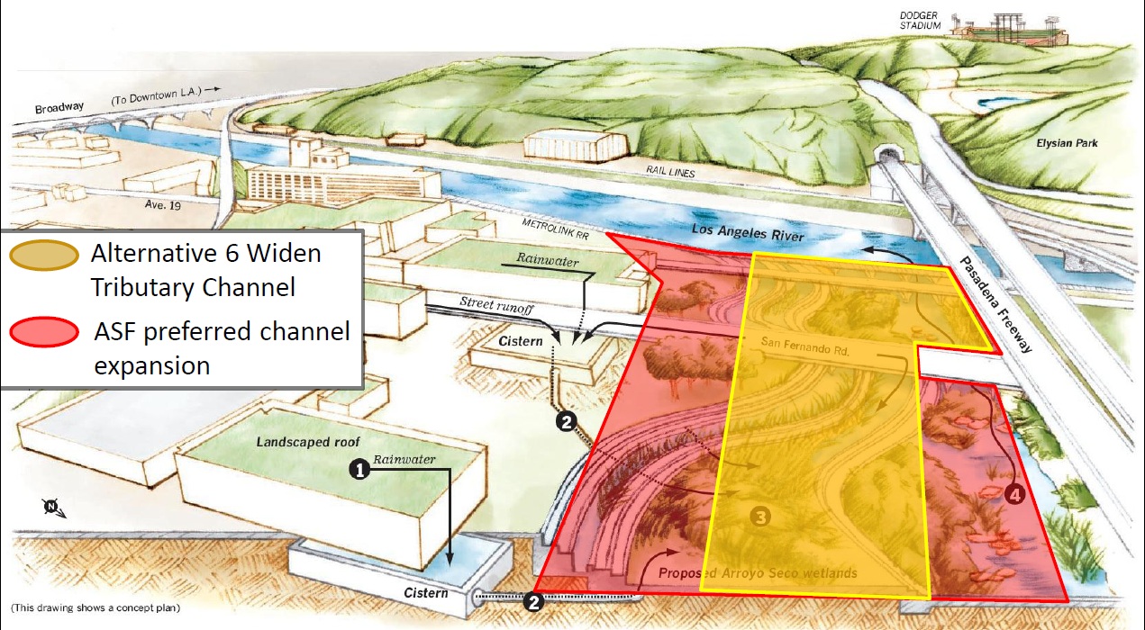
This figure overlays the modest channel widening contained in LAR Study alternative 6 and the expanded channel widening included in the ASF Preferred Plan. The ASF plan is much closer to the LA River Revitalization concept and allows for significantly greater habitat and stream values while improving public access.
Comparison of Cross Sections
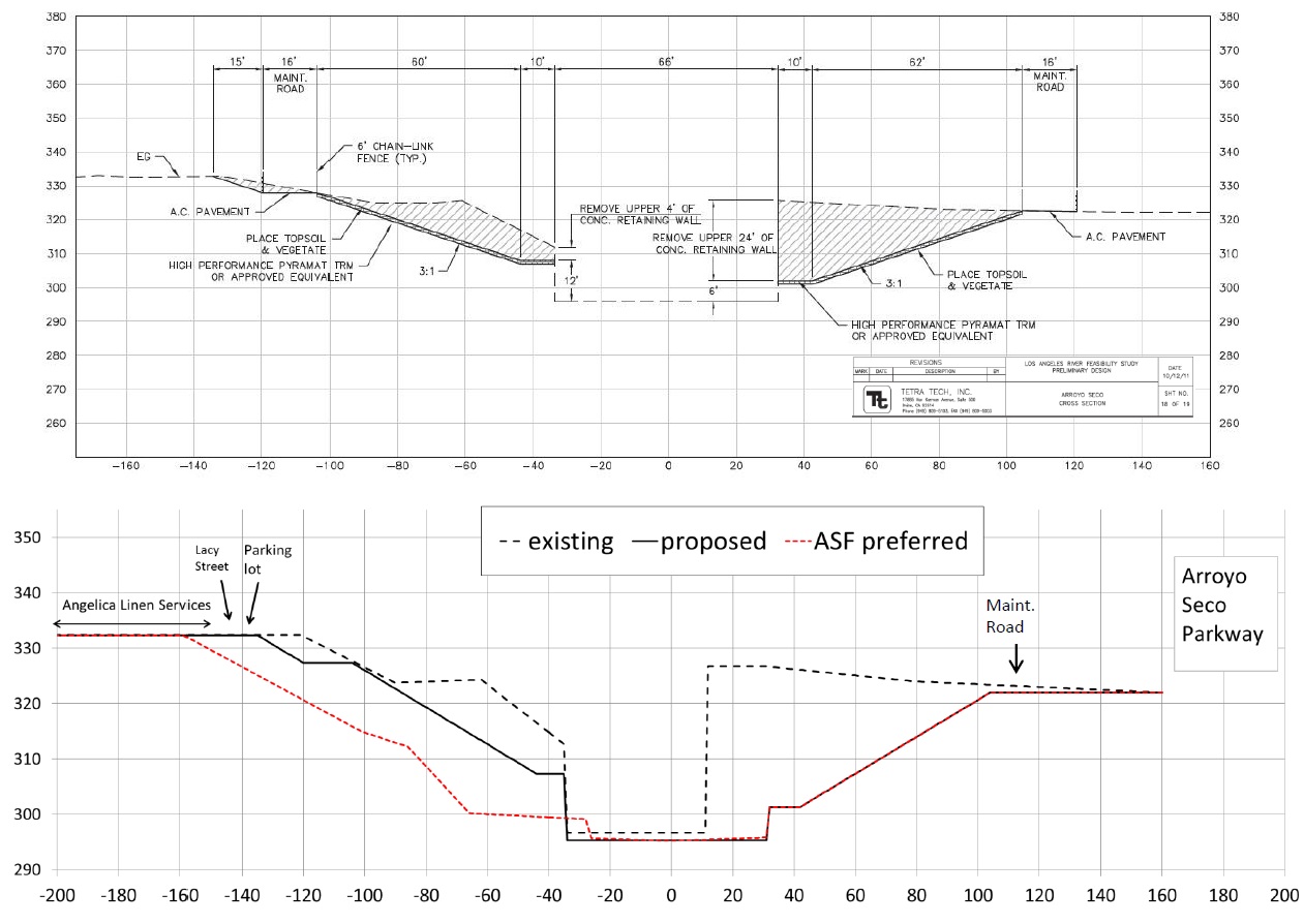
We have prepared an alternative Confluence cross section and here provide a comparison with the one prepared by Tetra Tech for the study.
The Tetra Tech cross section, two hundred and fifty feet upstream from the main stem of the LA River, expands the channel from fifty to sixty six feet wide. The ASF cross section shows an expanded stream zone area on the south side of the stream approximately 50 feet wider than the Tetra Tech preliminary design. This would provide an excellent corridor for riparian habitat and additional flood capacity. On the north side of the stream, the ASF Preferred Plan would also remove the current twenty four foot high channel retaining wall. The ASF cross section includes the expanded Confluence Park area presented in the USGS study and the Cornfields/Arroyo Seco Confluence Specific Plan on the south. Currently the mouth of the Arroyo is eighty feet wide. The ASF Preferred Plan would restore the historic channel width to over two hundred feet with related habitat and flood benefits.


.JPG)